Skip to Content
The Challenge
Newicon 1 0
The Challenge

Organizing winter services efficiently

Mobilität
Mobility
Sicherheit 
Security
Stadtplanung
Urban Planning

Organizing winter services efficiently

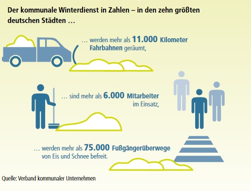
Snow and icy roads pose challenges for cities and municipalities every winter: because they are obliged to make roads and sidewalks accessible to everyone as soon as possible. Icy and snow-covered roads increase the risk of accidents, lead to traffic jams and cause interrupted supply chains. Effective clearing of snow and ice is therefore essential for traffic and supply safety in the respective region. Coordinating winter services is a complex undertaking: Which roads are affected? Where should they be cleared first? And how long will the supply of road salt last?

image description

Riding a bike in winter? No problem if roads are well cleared! ©iStock

Conventional weather forecasts offer orientation, but are only really reliable a few days in advance and do not allow any conclusions to be drawn about the situation in individual streets, for example. Better coordination of winter services is made possible by the use of smart technologies, the combination of which forms the basis for more resource-efficient operations.

Approaches

  • More efficient route planning can be facilitated by smart routing software.
  • Sensors on the road as well as local weather stations provide accurate data on weather conditions as well as on snowfall and icy conditions at their installation site.
  • Salt storage levels can be digitally recorded to prevent bottlenecks.

Opportunities

  • Cleared roads reduce the risk of accidents and ensure greater planning reliability with regard to materials if storage levels are monitored digitally.
  • Reduced workload for winter service employees, as work is only carried out when necessary and, for example, control trips are no longer necessary.
  • Well-cleared roads and cycle paths enable bicycles to be used even in winter.

Solution(s)

Smart routing and digitalization of winter services

image description

Open Weather Map API

Data

Which SDGS are addressed?

In order to create globally sustainable structures, the member states of the United Nations have set themselves 17 goals by 2030, which are set out in the 2030 Agenda for Sustainable Development.

image description
image description
image description
image description

In the Open Urban Data Community, municipal actors can network with each other, engage in conversation, and work together on implementations. Benefit from the cost-free formats for the community!

You would like to be a part of the community?

image description

Adoptable realizations

Already successfully realized by community members or currently being implemented:
image description

Freiburg - Live traffic visualization

image description

ASCEND research project clean energy districts

image description

Shared Mobility Dashboard for Cologne

image description

Mainz - Improve e-parking

Previous
Next
Back to top